22.22.040 Downtown commercial neighborhoods.
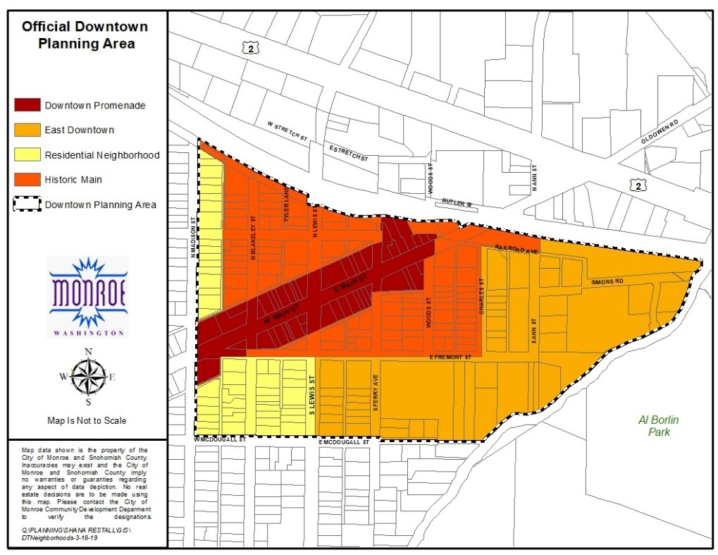
A. Establishment of Neighborhoods. The downtown commercial zoning district is subdivided into four distinct neighborhoods. Each neighborhood is intended to implement specific aspects of the comprehensive plan that pertain to the downtown planning area and contains a unique mix of uses and zoning regulations, as described in this chapter. The four neighborhoods in the downtown commercial zoning district are residential neighborhood (RN), historic main area (HM), east downtown neighborhood (ED), and the downtown promenade (DTP). The neighborhoods within the downtown commercial zoning districts are established as follows:
1. Residential Neighborhood (RN). The residential neighborhood frames the western edge of the historic main area and contains existing single-family houses, multifamily buildings, and some commercial uses. This mix of uses is appropriate for this neighborhood, as a transitional edge between single-family neighborhoods and the historic main area, to provide a setting for small businesses and close-in housing options. Future redevelopment in this area will provide a mix of uses. Residential uses in this neighborhood are limited to single-family residences and multifamily dwellings.
2. Historic Main Area (HM). The historic main area encompasses the blocks along Main Street between Madison Street and the railroad tracks and along Lewis Street between Fremont Street and the railroad tracks (except those areas within the downtown promenade per subsection (A)(3) of this section). The historic main area will be the core area for specialty commercial uses that serve the entire community and even the region. The goal for this area is to continue to have a high concentration of retail, dining, and entertainment functions, while accommodating professional services and some residential housing. Cultural and recreational facilities should also be a part of the area’s mix of uses.
3. Downtown Promenade (DTP). The downtown promenade area encompasses the entire ground and/or street level portion of all buildings facing Main Street between Madison Street and Woods Street, specifically including without limitation all commercial tenant spaces and suites located on the ground and/or street level of such buildings, and shall be considered a “promenade” within the historic main subarea of the downtown commercial district. The goal for this area is to have those land uses that promote pedestrian activity and interaction.
4. East Downtown Neighborhood (ED). The goal for this neighborhood is to promote an “urban village” character that contains pedestrian scale amenities and high-quality mixed use and high density residential development. Land uses will provide for a concentration of commercial, residential, and civic functions. Civic functions may include recreational and arts uses as well as education-related activities. The east downtown neighborhood should contain significant, well-designed parks and open space. There are opportunities to make use of natural amenities along the eastern edge of the area that would make this a distinctive and appealing location for in-town housing. There are also opportunities to provide additional urban, civic green spaces within convenient walking distance of the historic main area. This combination of uses is necessary to promote the greater downtown Monroe area as a regional destination for specialty retail, dining, and entertainment. Areas along Woods Creek and the east downtown neighborhood are encouraged to provide enhanced pedestrian and bicycle connectivity. Also proposed along Woods Creek is an area for an overlook and water access at the creek itself, which would be linked into the enhanced bike and pedestrian ways. Areas of the east downtown neighborhood, which are within the Woods Creek shoreline area, will have some development constraints due to the natural sensitivities of the creek side areas.
B. Official Downtown Planning Area Zoning Map. The official downtown planning area zoning map shows the boundaries of the downtown planning area and delineates the four distinct neighborhoods in the downtown commercial zoning district. This map shall be supplemental to the current, official city of Monroe zoning map. Where uncertainty exists as to the boundaries of the downtown planning area and downtown commercial neighborhoods, as shown on the official downtown planning area zoning map, the rules defined in MMC 22.14.040, Zoning district boundary determination, shall apply.
(Ord. 024/2022 § 1; Ord. 005/2019 § 10 (Exh. B))